- +27 12 841 1911
- 280 Pretoria Street, Silverton, Pretoria

Namibia
Geoscience for Diplomacy
Allocate significant resources to transfer mapping and research skills to the GSN and CGS geologists.
Namibia Geological Mapping Project
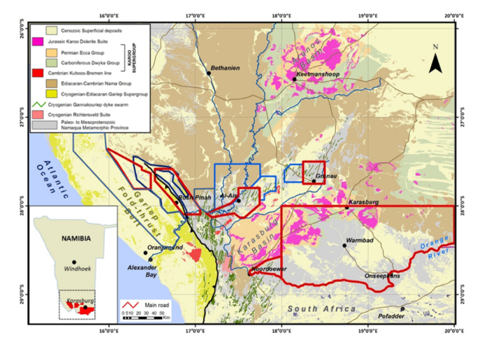
The CGS has been carrying out geological mapping for, and in collaboration with, the Geological Survey of Namibia (GSN)/Ministry of Mines, Namibia, for the past five years. The main aim of the mapping has been to develop a unified lithostratigraphy and tectonostratigraphy across South Africa–Namibia border to better understand the rock units and structures controlling mineralisation in the region, specifically regarding deposits of Cu, Pb, Zn, U, Ta, Nb, REE, Li and W. The project has thus far delivered more than 40 new 1:50 000-scale geological maps and explanations covering an area of about 25 000 km2. The project has also produced the first hiking and geology map of the Fish River Canyon in collaboration with Peter Slingsby Maps. The geological mapping is supported by U-Pb geochronology, Sm-Nd and Rb-Sr isotope geochemistry, whole-rock major-, trace- and rare-earth element geochemistry and structural investigations. The CGS has proposed a modified geodynamic model for the central/western Namaqua Metamorphic Province based on the mapping and research datasets. In addition to the scientific work, the project has allocated significant resources to transfer mapping and research skills to the GSN and CGS geologists.

Locations of completed geological mapping overlain on a simplified geological map of southern Namibia and the northwestern part of the Northern Cape. Red: 2013–2016 and blue: 2016–2018 mapping campaigns.
