- +27 12 841 1911
- 280 Pretoria Street, Silverton, Pretoria


Country
South Africa
Sector
Mineral and Energy Resources
Project Aim
To boost the South African blue economy.
Marine Mapping Project
The South African offshore area is larger than the country’s onshore region and has the potential of being more than doubled if South Africa’s Extended Shelf Claim is ratified by the United Nations. The overarching objective of the Marine Geoscience Programme of the Council for Geoscience is to boost the South African blue economy. This project aims to create the “real map” of South Africa, seamlessly spanning the onshore area to the outermost edge of the country’s offshore territory. The programme will provide full coverage of the country’s Exclusive Economic Zone (EEZ), using a suite of vessels designed for a range of ocean depths and applying five marine geophysical methods. These techniques are multibeam bathymetry, side-scan sonar, marine magnetics, medium-penetration subbottom profiling and gravity.
The imperatives of the programme are aligned with the mandate of the Council for Geoscience and the objectives of Operation Phakisa, while adhering to global standards in marine geophysics and hydrography. The research of the programme is enriched by harnessing a strong global network and aims to maximise outputs from a relatively small budget. The Marine Geoscience Programme comprises six focus areas, each of which carries equal priority. These are innovation in mapping, technological advancement, capacity building and training, knowledge through research, data management and ocean governance.
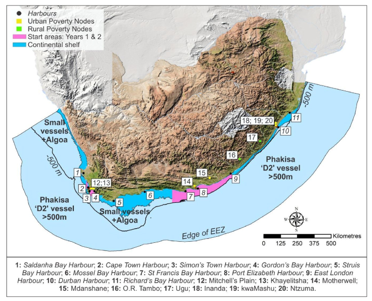
Areas of work for the Marine Geoscience Programme for years 1–3 (magenta) within the context of the locations of South African harbours and poverty nodes.
There is a growing awareness across a variety of maritime sectors in South Africa that an improved regional and local understanding of the marine environment is both essential and central to future strategic planning and policy decisions. Management tools are critical to ensuring that living and mineral resources alike are utilised sustainably. Fundamental to management and planning are baseline regional bathymetric and substrate data. Similarly, strengthening South Africa’s legal framework through the development of an offshore mining code is essential to the sustainable deployment of South Africa’s blue economy. Indeed, in order to embrace a sustainable approach to the exploitation of natural resources on our continental shelf and adjacent seabed area, we require good-quality baseline data. Thus, in addition to aligning itself with principles outlined in the NDP in support of sustainable growth and socio-economic development, the Marine Mapping Programme will ensure that South Africa is well positioned in terms of achieving the international objectives outlined in the United Nations 2030 Sustainable Development Goals and the 2060 agenda of the African Union.
The broad aims of the Marine Mapping Programme are:
- Mapping South Africa’s EEZ using five different marine geophysical methods.
- Producing onshore-offshore geological maps, at a scale of 1:50 000.
- Developing a strong marine geoscience group at the Council for Geoscience with an international reputation.
- Fostering partnerships and embracing collaboration.
- Gaining a clear understanding of marine geoscientific processes on the continental shelf in selected strategic areas.
- Contributing to matters related to ocean governance.
Contact Us
- 280 Pretoria St, Silverton, Pretoria, 0184
- +27 12 841 1911
- info@geoscience.org.za
-
Report any unethical behaviour
0800 16 13 17
geoscience@whistleblowing.co.za

Manage Cookie Consent
To provide the best experiences, we use technologies like cookies to store and/or access device information. Consenting to these technologies will allow us to process data such as browsing behavior or unique IDs on this site. Not consenting or withdrawing consent, may adversely affect certain features and functions.
Functional
Always active
The technical storage or access is strictly necessary for the legitimate purpose of enabling the use of a specific service explicitly requested by the subscriber or user, or for the sole purpose of carrying out the transmission of a communication over an electronic communications network.
Preferences
The technical storage or access is necessary for the legitimate purpose of storing preferences that are not requested by the subscriber or user.
Statistics
The technical storage or access that is used exclusively for statistical purposes.
The technical storage or access that is used exclusively for anonymous statistical purposes. Without a subpoena, voluntary compliance on the part of your Internet Service Provider, or additional records from a third party, information stored or retrieved for this purpose alone cannot usually be used to identify you.
Marketing
The technical storage or access is required to create user profiles to send advertising, or to track the user on a website or across several websites for similar marketing purposes.
Good Friday